InterWest Wildlife has ben conducting
aerial telemetry projects in the Inter-Mountain West for over 14 years. Telemetry
projects have been conducted for a wide range of clients, on several species,
 and over a variety of terrain types. Clients have included academic researchers,
government agencies, and private landowners. Species have included big game,
carnivores, and TES. Aerial telemetry studies have been over rugged and remote
mountains, rugged foothills, valley bottoms, island mountain ranges, and playa
deserts.
and over a variety of terrain types. Clients have included academic researchers,
government agencies, and private landowners. Species have included big game,
carnivores, and TES. Aerial telemetry studies have been over rugged and remote
mountains, rugged foothills, valley bottoms, island mountain ranges, and playa
deserts.
InterWest Wildlife has logged
well over a thousand hours flying aerial telemetry in the Rocky Mountains
and the Inter-Mountain West. InterWest's pilot is a very experienced mountain
pilot and  commercial
pilot. In addition he is also a certified wildlife biologist with a thorough
understanding of the research aspect of telemetry studies. Our wildlife biologist/pilot
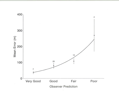
has been tested in the accuracy of the radio relocations obtained (see Supporting
Research Web Page). The accuracy of radio-telemetry
relocations is determined by the research goals and budget. Decreasing the
error distance generally takes additional flight time. Accuracy in flat terrain
can be less than 1 meter while accuracy in steep, broken, mountainous terrain
can be less than 10 meters. Research has also shown that our pilot can accurately
predict the relocation error.
commercial
pilot. In addition he is also a certified wildlife biologist with a thorough
understanding of the research aspect of telemetry studies. Our wildlife biologist/pilot
has been tested in the accuracy of the radio relocations obtained (see Supporting
Research Web Page). The accuracy of radio-telemetry
relocations is determined by the research goals and budget. Decreasing the
error distance generally takes additional flight time. Accuracy in flat terrain
can be less than 1 meter while accuracy in steep, broken, mountainous terrain
can be less than 10 meters. Research has also shown that our pilot can accurately
predict the relocation error.