
ACCURACY OF
AERIAL TELEMETRY LOCATIONS IN MOUNTAINOUS TERRAIN
GLEN F. GANTZ, InterWest Wildlife and Ecological Services, Inc., 11255 North
2000 East, Richmond, UT 84333
L. CHARLES STODDART, Denver Wildlife Research Center, Animal and Plant Health
Inspection Service, U.S. Department of Agriculture, Utah State University,
Logan, UT 84322-5295
Abstract: We measured the accuracy of an aerial telemetry system in
the Bear River mountains of northern Utah and southern Idaho. We determined
accuracy by comparing known and estimated transmitter locations. Accuracy
(x = 89 m) may have improved with observer/pilot experience. Variations in
accuracy can be attributed to evaluation apprehension, weather, air turbulence,
altitude above terrain, and identifiability of topographic features. Among
terrain types (flats, canyons, ridges, and hillsides) we were able to locate
transmitters on ridges more accurately than in canyons (P = 0.01). The observer/pilot's
categorical prediction of how accurately he located each transmitter (very
good, good, fair, and poor) was related (P = 0.01) to observed error.
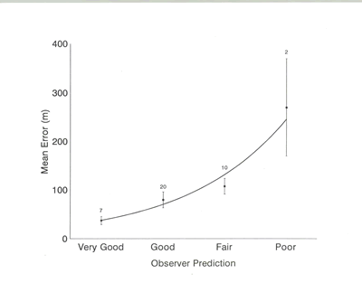
Fig. 2. Relationship
of mean aerial telemetry location erro and the observer/pilot's prediction
of how well he located transmitters in the Bear River mountains, northern
Utah and southeastern Idaho, 1987-89. Sample size is indicated above each
point. ME = 20.15e 0.630P, r = 0.98
Article available upon request